
Hydrogeologic Modeling
Our Project Experience
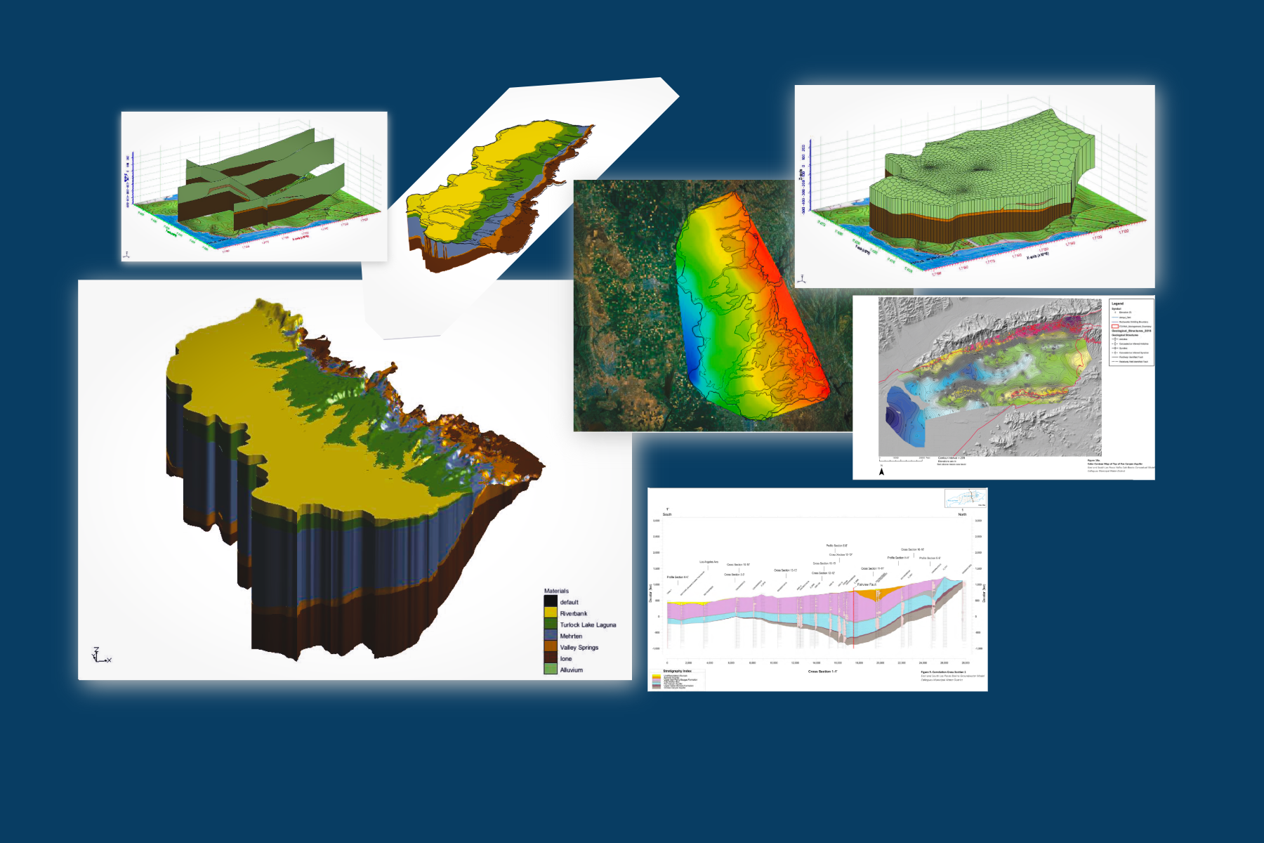
San Bernardino Basin Model (SBBM) Update & Steering Committee
San Bernardino Valley Municipal Water District | San Bernardino, California
Eros supports the ongoing update of the San Bernardino Basin Model (SBBM), a key regional decision-support tool used by the San Bernardino Valley Municipal Water District (SBVMWD) for safe yield assessments and sustainable groundwater management planning. Working in collaboration with S.S. Papadopoulos & Associates, he provided technical review and strategic guidance as part of the project’s Steering Committee.
His role included evaluation of the model framework, hydrostratigraphic layering, calibration datasets, and boundary conditions to improve model accuracy and predictive performance. Eros also analyzed historical recharge and production simulations, identifying opportunities to enhance the model’s representation of managed recharge operations, fault-controlled groundwater flow, and inter-basin connectivity. His recommendations have informed model refinements and increased stakeholder confidence in its application for basin sustainability, recharge optimization, and long-term water resource planning.
Chino Basin Model Peer Review and Basin Safe Yield Evaluation
Chino Basin Watermaster | Rancho Cucamonga , California
Eros supports S.S. Papadopoulos & Associates in conducting an independent peer review of the Chino Valley Groundwater Model (CVM) and its application to the Chino Basin Watermaster’s safe-yield evaluations. The review addresses Board and stakeholder concerns regarding boundary conditions, recharge representation, and applied-water/return-flow assumptions used in basin management analyses.
He evaluated model calibration, hydrostratigraphic structure, and boundary condition implementation to ensure scientific defensibility and transparency. Eros also developed a framework to identify and prioritize “uncertainty hot spots,” including areas such as the Mount Rubidoux flank and the Rialto-Colton interface, where model sensitivity is highest. His recommendations support refinement of the model for improved predictive reliability and provide a roadmap for long-term basin planning, management, and regulatory compliance under the Sustainable Groundwater Management Act (SGMA).
Las Posas Basins SGMA Groundwater Sustainability Plan 3D Hydrostratigraphic Conceptual Model
Calleguas Municipal Water District | Moorpark, California
Eros served as the lead hydrogeologist and technical developer for the three-dimensional hydrostratigraphic conceptual model (HCM) of the Las Posas Basin in Ventura County, supporting the Fox Canyon Groundwater Management Agency (FCGMA) and Calleguas Municipal Water District in meeting Sustainable Groundwater Management Act (SGMA) requirements. The 66‑square‑mile basin, extending more than 3,500 feet in depth, was digitally modeled to refine understanding of groundwater–surface water interactions, aquifer geometry, and resource availability for sustainable yield and water budget estimation.
He integrated oil and gas well records, geophysical and lithologic logs, and field mapping of paleostratigraphic, lithostratigraphic, and mesoscopic structural features to construct a high‑resolution subsurface framework. Eros applied geostatistical and 3D modeling tools, including RockWorks, Leapfrog, Petra, ArcGIS, and gINT—to synthesize disparate datasets into a cohesive geologic model used to inform basin management and numerical flow modeling. His work strengthened the scientific foundation of the Las Posas Groundwater Sustainability Plan and enhanced stakeholder confidence in regional water resource decision‑making.
Development of a Digital Three-Dimensional Hydrogeologic Conceptual Model (HCM)
Tinker Air Force Base, Oklahoma City, OK
Eros led the development of a digital three-dimensional hydrogeologic conceptual model (HCM) for Tinker Air Force Base, one of the U.S. Air Force’s largest active installations with complex subsurface conditions and legacy contaminant plumes. The model integrated multiple aquifer systems, saturated zones, aquifer test datasets, geophysical interpretations, and groundwater surface and chemistry data to support future quantitative groundwater flow and contaminant transport modeling.
The 3D digital HCM served as a foundational decision-support tool for evaluating contaminant migration pathways, refining site conceptualization, and prioritizing remedial investigation areas under CERCLA oversight. Eros presented key findings at the Battelle Conference, emphasizing data integration methods, uncertainty reduction techniques, and the model’s role in advancing adaptive groundwater management and remediation planning across the installation.
Los Angles Forebay Perchlorate Cleanup Project
Water Replenishment District of Southern California | Lakewood, California
Eros supported the Water Replenishment District of Southern California (WRD) in one of the most technically complex perchlorate investigations in the state, conducted in collaboration with multiple regulatory agencies through the Los Angeles Forebay Groundwater Task Force. The project addressed elevated perchlorate concentrations within the Forebay aquifer system—among the highest detected statewide—occurring in deep, coarse-grained hydrostratigraphic zones hydraulically connected to the Central and West Coast Basins (CBWCB). This connectivity posed an imminent risk of plume migration into critical regional supply aquifers, with two municipal production wells already impacted downgradient of the City of Vernon.
Eros led the hydrogeologic design and oversight of an expanded triple-nested monitoring well network to refine the three-dimensional characterization of plume extent and transport pathways. He also contributed to the design and field oversight of remedy progress and extraction wells, supporting WRD’s long-term containment strategy. His work included development and calibration of conceptual and numerical groundwater flow and solute transport models, integrating data from nested wells and aquifer testing to guide remedial strategy, prioritize monitoring, and inform long-term basin management under Proposition 1 funding.
Los Angeles River Channel Hydraulic Assessments, Water Quality Monitoring, and Digital Modeling
U.S Corps of Engineers | Los Angeles, California
Eros supported the U.S. Army Corps of Engineers in conducting hydraulic, environmental, and digital modeling evaluations for the Los Angeles River (LAR) channel, focusing on the Glendale Narrows reach, one of the few remaining soft-bottom sections of the river system. The Corps’ maintenance area included both rectangular and trapezoidal concrete-lined segments and a 6.4‑mile soft-bottom channel stabilized with grouted stone and concrete levees.
Eros led NASSCO-compliant assessments of stormwater side drains and monitored water quality compliance during channel maintenance operations to ensure adherence to federal and state discharge requirements. He also developed a comprehensive digital model and database of the LAR channel geometry, hydraulics, and conveyance features to support ongoing maintenance planning, sediment management, and habitat preservation objectives within this critical urban watershed.